Understand Flood Risks and Prepare with 24 Hour Flood Fighters
When we talk about flood risk in Nashville, TN, we’re really talking about how likely it is that your home or business could get damaged by water from heavy rain, river overflow, or surface runoff. This guide explains how those risks might impact you. Recent heavy rains and big floods have made it even more urgent for everyone to be prepared. We’ll show you how to figure out your risk, understand flood maps, and take practical steps to protect your property.
You’ll learn the main reasons for flooding in Nashville, review the city’s flood history, and use tools like FEMA flood zones and Metro Water Services maps to pinpoint local risks. We’ll also look at how climate trends are changing flood probabilities and guide you through important preparedness actions. Plus, we’ll give you clear, step-by-step actions to take before, during, and after a flood, and explain when to call . For urgent restoration needs, local professionals offer water damage restoration and mold remediation, and our section on emergency restoration describes how these services support your recovery. Our goal is to give homeowners and business owners in Nashville and Murfreesboro the clear, actionable information you need to reduce damage, navigate insurance, and recover quickly if flooding occurs.
What Are the Main Causes of Flooding in Nashville, TN?
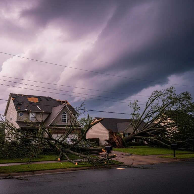
Flooding in Nashville happens when there’s just too much water – from heavy rain or rivers overflowing – for our rivers, storm drains, or even the ground to handle. This leads to water pooling or rivers spilling over their banks. Heavy, concentrated rainfall overwhelms drainage networks and causes both sudden flash floods and longer-lasting river floods, making storm intensity a primary driver of local floods. The Cumberland River and its smaller streams can send huge amounts of water into low-lying areas. Plus, all the concrete and buildings in the city mean water can’t soak into the ground, making floods deeper and faster. Knowing how this works helps you decide what to do first, like improving your drainage or raising important systems, to protect against both quick flash floods and longer river floods.
How Do Nashville's Geography and Rivers Influence Flood Risk?
Nashville’s unique landscape, with its valleys and rivers, naturally guides water from higher areas into the Cumberland River basin and its many streams. This means flood risk is highest in neighborhoods right along these waterways and in low-lying areas. The Cumberland River, Harpeth River, and smaller creeks define natural floodways where water flows when banks overflow. These floodplains historically absorb peak flows but also place riverside properties at higher risk. Neighborhoods next to these waterways experience greater flood depths and longer durations when major storm systems stall or when upstream runoff raises river levels, increasing the need for property-specific risk assessment. If you live near these waterways, it’s smart to take steps like raising your utilities, getting the right insurance, and improving your property’s drainage to be less vulnerable.
What Role Does Urban Development Play in Increasing Flood Risk?
When we build more in the city – think roofs, driveways, and pavement – we create ‘impervious’ surfaces. These surfaces stop water from soaking into the ground, making it rush into storm drains and streams faster. This increases the chance of both flash floods and river floods. Many older storm drains and pipes weren’t built for today’s extreme rainfall. They can get overwhelmed, leading to backups, flooded streets, and clogged culverts. Changes in land use that reduce natural floodplain storage or remove vegetated buffers worsen downstream flood impacts, particularly during intense storms. To tackle these risks, we need city-wide upgrades, property owners adding things like permeable driveways, and everyone keeping gutters and drainage clear. It’s all about making sure water can flow where it needs to go.
- Urban development increases runoff and peak streamflow during storms.
- Impervious surfaces reduce infiltration, raising flood heights downstream.
- Undersized stormwater systems and blocked culverts cause localized flooding.
Because of these development factors, it’s really important for you to check your property’s drainage and work with local agencies to reduce flooding in your neighborhood.
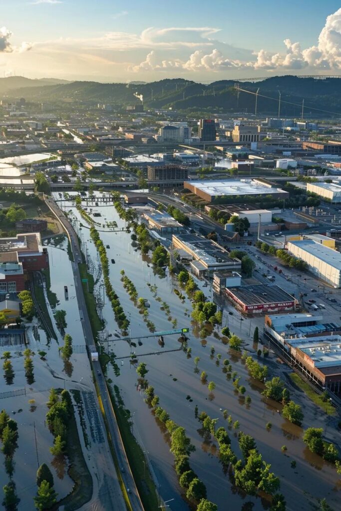
What Is Nashville's Flood History and What Major Flood Events Have Shaped the Region?
Nashville has a history of severe floods that show just how fast heavy rain and overflowing rivers can cause huge damage. Looking back at these events teaches us a lot about how to prepare. Major floods have caused rapid rises in river levels and extensive property losses, leading to updates in mapping, emergency planning, and infrastructure investments. By studying past floods, we can see which neighborhoods are hit repeatedly and how quickly we respond, how good our warnings are, and what people do to protect their homes all affect how fast we recover. Learning from these past floods helps you decide what’s most important, like getting flood insurance, raising your utilities, and having clear records ready for any claims.
What Happened During the 2010 Nashville Flood and Its Impact?
The 2010 flood brought incredibly heavy rain in a short time, causing rivers to rise fast and low-lying areas to flood everywhere. This led to massive property damage and long recovery times for many. It showed us how vulnerable both our rivers and city drainage systems were, and how quickly water runs off saturated ground to create much deeper floods than expected. Businesses were shut down, and many needed long-term rebuilding. This pushed us to improve flood maps, community outreach, and how we coordinate emergency responses. These lessons really emphasize how important it is to protect your own property and to evacuate or take action quickly when warnings come out.
Uneven Flood Experiences in Nashville: 2010 Event Analysis
Using the 2010 Nashville Davidson County Tennessee flood event, the differential community impacts of flooding and their spatial variations are analyzed. Guided by social vulnerability and hazards methodologies, census block data from the 2012 American Community Survey, ArcGIS imagery and redlining maps are used to develop a social variability index using principal components analysis. Components were overlaid on all 98 Nashville census tracts for Davidson County to reveal that flood impacts were inequitably distributed with socioeconomically and racially marginalized households the most severely impacted from flooding. The consequence is that historical processes of segregation and marginalization continue to shape uneven flood impacts in Nashville. Examining the ways vulnerable populations experience severe precipitation events is needed particularly as extreme events are expected to intensify in the future.
Uneven experiences of urban flooding: examining the 2010 Nashville flood, G Linscott, 2010
The intense rainfall during the 2010 event was a significant meteorological phenomenon that overwhelmed Nashville’s infrastructure. Scientific analysis has delved into the specific atmospheric conditions that led to such extreme precipitation.
Physical Processes of Nashville’s 2010 Flood Rainfall
A multiscale analysis is conducted in order to examine the physical processes associated with heavy flooding rainfall in Nashville, Tennessee, and vicinity during 1–2 May 2010, during which Nashville, Tennessee, experienced significant flooding.
Physical processes associated with heavy flooding rainfall in Nashville, Tennessee, and vicinity during 1–2 May 2010: The role of an atmospheric river and mesoscale …, BJ Moore, 2010
Further examination of the 2010 storm event revealed that rainfall totals in some areas surpassed even the most extreme historical estimates, highlighting the potential for unprecedented flood events.
Extreme Rainfall Event Assessment: Nashville, TN May 2010
The maximum rainfall totals for some durations during the May 1–3, 2010 storm event at Nashville, TN exceeded the 1,000-year rainfall values from NOAA, indicating an extreme rainfall event with significant flood potential.
Assessment of the extreme rainfall event at Nashville, TN and the surrounding region on May 1–3, 2010, BD Keim, 2010
How Did the 2021 Middle Tennessee Floods Affect Nashville and Surrounding Areas?
The 2021 Middle Tennessee floods saw record rainfall in some areas, causing both sudden flash floods and rivers to stay high across many counties. This really stretched our emergency services and showed how much communities rely on each other during recovery. Unlike floods from just one river, the 2021 storms hit many different streams and rivers all at once. This caused all sorts of damage – basements flooded, sewers backed up, roads washed out – making it tricky to decide what to fix first. Because so many areas were affected, it highlighted the need for coordinated help between communities, stronger infrastructure, and clear advice for homeowners on what to document and how to act immediately. These events reinforced that both preparing your own home and planning across the whole region are crucial to reduce future damage.
What Lessons Can Be Learned from Past Flood Events in Nashville?
Past floods clearly show that early warnings, quick evacuation options, and protecting your property can save lives and reduce losses. Plus, having insurance and good records after a flood really speeds up recovery. Things like raising important systems, regularly clearing drainage paths, and adding green spaces in communities make us more resilient and save money in the long run. It’s also super important to keep your emergency plans and contact lists updated, practice your evacuation routes, and know when to call professional restoration services if water gets into your home. These lessons will guide the practical steps we’ll cover later in the preparedness and recovery sections.
How Can Nashville Residents Identify Their Flood Risk Using FEMA Flood Zones and Maps?
To figure out your flood risk, start by looking at FEMA Flood Insurance Rate Maps (FIRMs) and local maps. These will tell you if your property is in a high-risk ‘Special Flood Hazard Area’ (SFHA) or a lower-risk zone. Once you know, you can take action on insurance and protection. FEMA maps show you flood zones, how high water might get during a ‘100-year’ flood (called Base Flood Elevations), and floodways. Understanding these helps you decide if you need to raise things, get insurance, or make other protective changes. Local tools from Metro Water Services and county maps often give you even more detail about neighborhood drainage and specific problem areas that FEMA maps might miss. So, using both gives you the best picture. The steps below will help you turn what you see on the maps into real actions for protecting your home and planning ahead.
What Are FEMA Flood Insurance Rate Maps and How Do They Apply to Nashville?
FEMA Flood Insurance Rate Maps (FIRMs) are the official maps that show flood hazard zones, how high floodwaters might get (Base Flood Elevations), and floodways. These maps impact what kind of insurance you need and building rules in Davidson County and nearby areas. FIRMs identify Special Flood Hazard Areas where the National Flood Insurance Program typically requires flood insurance for federally backed mortgages, and they provide base elevations used for design and permitting decisions. You should look up your property on the FEMA map service to find your zone code, and also talk to your local floodplain administrator to understand how these rules apply specifically to your area. Knowing your property’s FIRM designation helps you decide if you need flood insurance and if you should raise parts of your home or floodproof it.
This table compares common FEMA zone classifications, typical water depth implications, and practical owner implications for insurance and building.
| Flood Zone | Typical Water Depth/Behavior | Owner Implication |
|---|---|---|
| Zone AE | Subject to base flood with defined Base Flood Elevation (BFE) | High risk; NFIP insurance often required by lenders |
| Zone A (no BFE shown) | Floodplain without detailed BFE data; variable depths | Elevated risk; consult local maps and consider elevation |
| Zone X (shaded) | Moderate risk from 0.2% annual chance or reduced risk area | Lower risk but not no-risk; consider insurance and local drainage |
How Are Special Flood Hazard Areas Defined in Nashville?
Special Flood Hazard Areas (SFHAs) are the zones FEMA maps as having the highest chance of flooding during a ‘100-year flood.’ If your property is in one, there are specific rules for building and insurance, especially for new construction or big renovations. SFHAs typically include floodplains next to rivers and streams, as well as areas prone to pooling or backwater effects. Structures in SFHAs may face higher premiums and building requirements. If your property is in an SFHA, it means you should look into raising parts of your home, floodproofing, and usually getting flood insurance through the National Flood Insurance Program (NFIP) or a private company. Knowing these boundaries helps you compare the cost of making changes to your home against insurance costs and your ongoing flood risk.
Where Can You Access Local Flood Maps and Tools from Metro Water Services?
Metro Water Services offers local drainage maps, lists of stormwater infrastructure, and neighborhood-specific models. These add crucial details to FEMA maps about culverts, storm drains, and known problem spots, which is vital for understanding your property’s specific risk. These local resources help you identify chronic problem spots, learn about planned infrastructure projects, and request inspections or maintenance that can reduce immediate neighborhood risk. Contacting Metro Water Services with questions about your neighborhood or reviewing their drainage reports can give you practical maintenance tips and help you plan what to do on your property. Using both FEMA maps and Metro Water Services data gives you the most complete picture to make smart decisions about protecting your home and getting insurance.
How Does Climate Change Increase Flood Risks and What Are Future Projections for Nashville?
Climate change is making floods more likely in Nashville mainly by causing more intense rainstorms and changing weather patterns. This means we’re seeing both flash floods and river floods more often and more severely. Warmer air holds more moisture, leading to heavier rainfall during storms. This means what we used to call ‘100-year storms’ are becoming much more common. Because of this trend, past flood data doesn’t fully show our future risk. We need to adapt by raising building standards, improving our water storage and drainage, and making smart land-use decisions to reduce future damage. Understanding these predictions helps both you and city planners take steps that will work even as our climate continues to change.
What Is the Impact of Extreme Precipitation and "100-Year" Storms in Nashville?
A ‘100-year storm’ means there’s a 1% chance of it happening in any given year. But with more extreme rain, these storms are happening more often, increasing the risk of both flash floods and long-lasting river floods. We’re seeing more intense rain, which means more water running off and our drainage systems getting overwhelmed more often. This increases the chance of repeat flooding, even for properties once thought to be low risk. Recognizing this shift means you should think about better drainage designs, check if your insurance is still enough, and focus on protection measures that can handle bigger, more frequent storms.
How Are Flood Probabilities Changing Due to Urban Heat Island and Weather Patterns?
The ‘urban heat island’ effect can change local weather patterns, sometimes making storms over cities more intense and causing heavy rain to fall unevenly. This increases runoff and the chance of flash floods in developed areas. Combined with bigger climate trends, these small-scale climate effects can dump a lot of rain on city centers, causing severe local flooding that regional models might not always predict. This shows why things like green infrastructure, permeable surfaces, and city trees are so important. They help reduce the heat island effect and the way it makes storms worse. City planning that considers these factors can reduce how much water runs off and make our communities more resilient.
What Are the Latest Scientific Findings on Nashville's Flood Risk Trends?
Recent studies show that Middle Tennessee is getting noticeably more extreme rainstorms. The chance of historically rare floods is going up, and regional models suggest our infrastructure will be overwhelmed more often. Organizations conducting flood-risk research recommend updating flood maps, using climate-adjusted data for new designs, and focusing on natural solutions that help store water and slow down runoff. For you, the main takeaway is that what happened in the past might not fully predict future flood risks. This makes being proactive with protection and having the right insurance more important than ever.
What Are the Best Flood Preparedness and Mitigation Strategies for Nashville Homeowners and Businesses?

Being truly prepared means having flood insurance, protecting your property, making an emergency plan, and doing regular maintenance. This layered approach reduces your risk and helps you recover faster if a flood happens. Focus on these key actions: get the right flood insurance, build an emergency kit and evacuation plan, raise utilities and important systems, and keep drainage clear. This creates a strong defense that reduces damage and health risks. Simple steps like installing a sump pump with a battery backup, sloping your yard away from your foundation, and using flood-resistant materials in risky areas can significantly cut down on repair costs and recovery time. Below is a table summarizing common mitigation measures with recommended actions and priority levels to help you choose affordable, high-impact options.
| Mitigation Measure | Recommended Action | Priority |
|---|---|---|
| Flood Insurance | Verify NFIP or private policy coverage and limits | High |
| Sump Pump & Backup | Install automatic pump with battery backup and alarm | High |
| Elevation of Utilities | Raise HVAC, electrical panels, and appliances above BFE | Medium |
| Site Drainage & Grading | Regrade yard, clean gutters, and clear downspouts regularly | High |
Why Is Flood Insurance Essential and How Does It Work in Nashville?
Flood insurance covers damage to your property and belongings from floods, which standard homeowners policies usually don’t. If you’re in a mapped high-risk flood area (SFHA), your lender will often require it. The National Flood Insurance Program (NFIP) offers standard coverage, but private flood policies can give you other options or extra coverage. It’s smart to compare these and confirm how much coverage you have for your home and its contents. Buying enough coverage *before* a flood is crucial because policies often have waiting periods. Also, having good records of your belongings makes filing a claim much easier. Understanding what your policy covers helps you make smart choices about further protecting your home and knowing what costs you might have to pay yourself.
- Flood insurance protects against water inundation that standard policies exclude.
- NFIP policies provide baseline coverage; private policies can supplement limits.
- Timely purchase is essential because of policy waiting periods that can delay coverage.
These insurance considerations translate into concrete preparedness: confirm your zone designation, review policy details, and document your property inventory.
What Should Be Included in a Flood Emergency Kit for Nashville Residents?
A good flood emergency kit has everything you need for immediate survival, health, and important documents. This way, you can stay safe if you need to shelter in place or evacuate, and you’ll have the records needed for recovery and insurance claims. Make sure to include: water (a gallon per person per day for several days), non-perishable food, a flashlight with extra batteries, a first-aid kit, waterproof bags for important papers (like insurance), a battery-powered radio or alert device, and basic tools to shut off utilities if it’s safe to do so. Keep medications, copies of vital documents, and contact info for emergency services and your insurance agent all in one waterproof container, so you can grab it quickly. Update your kit every season and after you use it to make sure it’s always ready.
How Can Property Elevation and Drainage Maintenance Reduce Flood Damage?
Raising important systems like electrical panels, HVAC units, and water heaters, and using flood-resistant materials in basements, can save you from expensive repairs and long-term mold problems if water gets in. Routine drainage maintenance – like clearing gutters, checking downspouts, and making sure your yard slopes away from your foundation – keeps water flowing correctly and prevents puddles near your home. When elevation or major renovations aren’t practical, options like temporary flood barriers, sandbags, and reliable sump pumps can still offer good protection. Check with local authorities for rules on elevation and consider getting a professional assessment if your property is at higher risk.
What Are Key Steps to Take Before, During, and After a Flood in Nashville?
Before a flood: Know your flood zone, keep an emergency kit ready, document your valuables, raise key systems if you can, and get flood insurance if you need it. During a flood: Your safety is number one. Follow evacuation orders, never walk or drive through floodwaters, shut off utilities if it’s safe, and take photos of any damage once it’s safe to do so. After a flood: Document all damage carefully, start drying and cleaning up quickly to prevent mold, and contact restoration professionals for safe water removal and structural drying. Quick, documented action speeds up insurance claims and reduces the likelihood of persistent problems like mold.
- Before: Prepare an emergency plan, secure insurance, and install property-level mitigations.
- During: Follow evacuation and safety guidance; avoid contact with floodwater.
- After: Document damage, start drying procedures, and seek professional restoration where needed.
These staged actions align homeowner priorities with effective recovery steps and help preserve evidence for claims and repair planning.
After discussing preparedness strategies, you’ll recognize when protection isn’t enough and professional assistance is required; that’s when like 24 Hour Flood Fighters can provide fast, safe recovery and claims documentation.
When Flooding Occurs, How Can 24 Hour Flood Fighters Help with Emergency Restoration in Nashville?
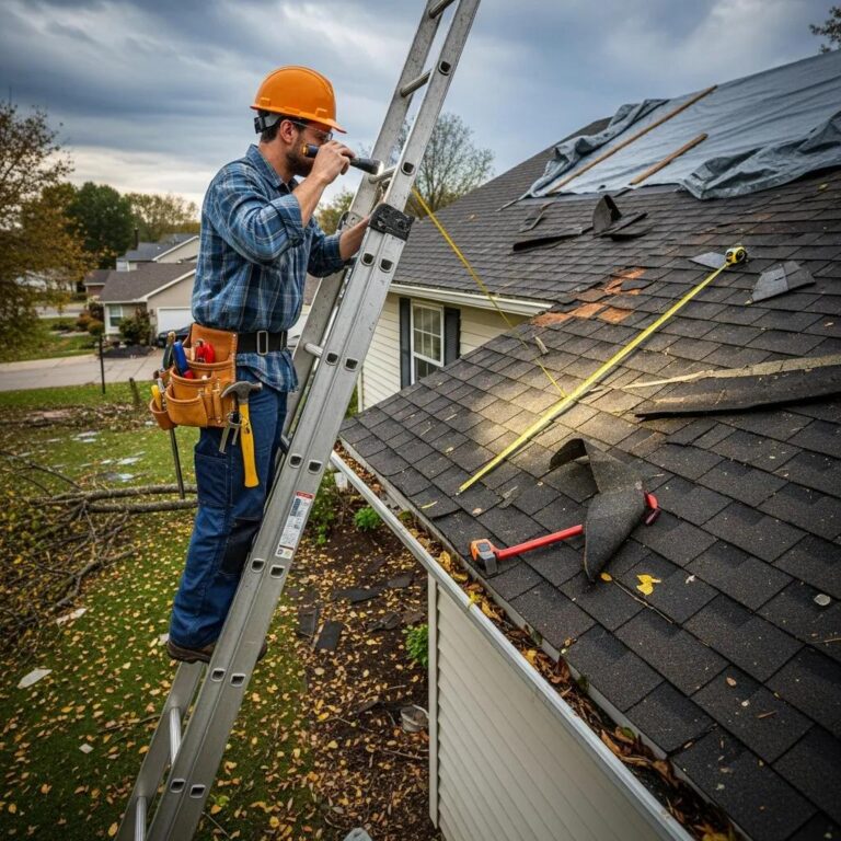
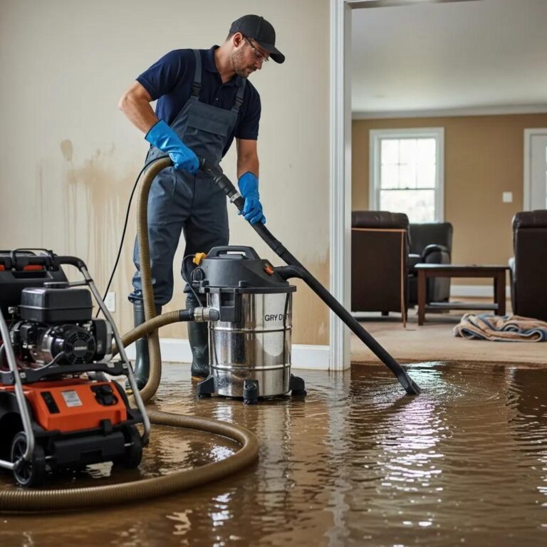
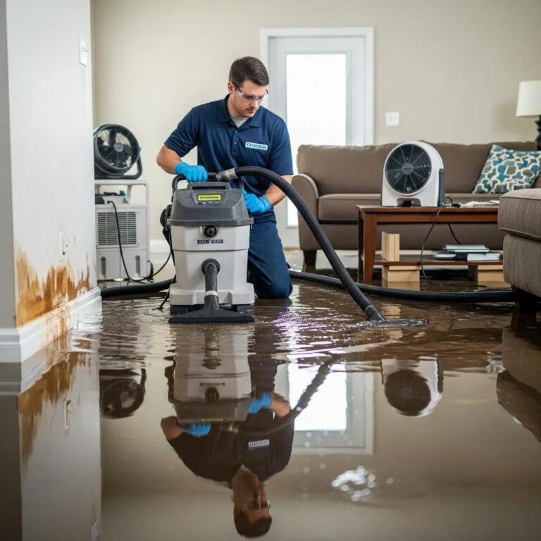
When water damage hits, 24 Hour Flood Fighters is here for homeowners and business owners across Nashville, Murfreesboro, and Middle Tennessee. We offer emergency water damage restoration and mold remediation, focusing on fast response and complete recovery. As a family-owned and operated emergency restoration company right here in Rockvale, TN, we’re available 24/7 for water extraction, structural drying, and mold remediation. We also help with insurance claims to make your recovery smoother. Our IICRC-certified technicians and A+ rating with the Better Business Bureau show our commitment to trained practices and earning local trust. We also offer , sewage cleanup, commercial restoration, and carpet cleaning. When you need fast, professional help, our certified technicians can reduce further damage and health risks from mold.
This table summarizes primary restoration service types, typical response expectations, and core deliverables to help homeowners choose the appropriate response.
| Service | Typical Response Time | Core Deliverables |
|---|---|---|
| Emergency Water Extraction | Immediate / within hours | Rapid water removal, structural drying, moisture mapping |
| Mold Remediation | 24–48 hours assessment | Containment, removal, HEPA cleaning, clearance testing |
| Structural & Contents Cleaning | Within 24–72 hours | Decontamination, odor control, content restoration |
What Water Damage Restoration Services Are Available After Nashville Floods?
focus on immediate action: quickly removing water, dehumidifying, and drying your property to stop further damage and mold. We use industrial pumps, air movers, and moisture meters to get the job done. Technicians use moisture mapping to pinpoint drying efforts, remove anything that can’t be saved, and handle cleaning and inventory of your belongings to help with insurance claims. Timelines vary, but acting quickly within the first 24–72 hours makes a huge difference, drastically cutting repair costs and stopping mold from spreading. You’ll want to document everything, keep receipts for any emergency purchases, and follow our guidance on what needs to be removed and how to prioritize drying.
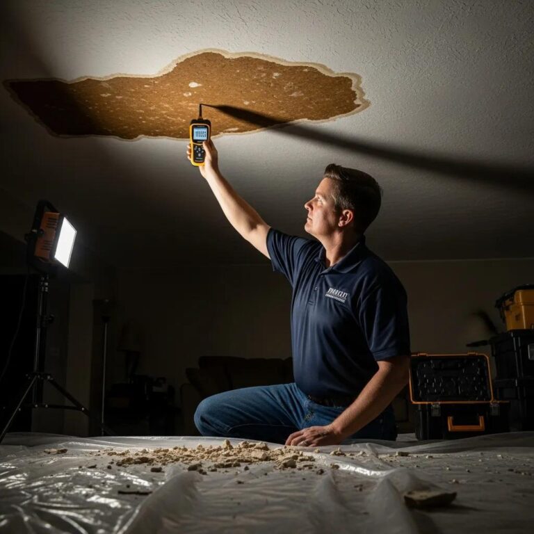
How Does Mold Remediation Prevent Health Risks Following Flood Damage?
Mold can start growing on damp materials within just 24–72 hours after water gets in. It produces spores and gases that can cause allergic or breathing problems, especially for sensitive people. involves assessing the problem, containing the affected area, removing moldy materials, using HEPA vacuums for thorough cleaning, and then verifying that mold levels are back to normal. Our IICRC-certified procedures prioritize safety and proper drying to prevent mold from coming back. Fast remediation also reduces long-term exposure and structural damage. Getting mold specialists involved early is crucial for controlling health risks and making your indoor environment safe again.
How Does 24 Hour Flood Fighters Assist with Insurance Claims for Flood Damage?
We help homeowners by documenting damage with moisture readings, photo inventories, and professional estimates. This supports clear communication with adjusters and insurers, helping to speed up your approval and settlement. Our restoration professionals can give you detailed reports that meet industry standards, advise on temporary repairs, and work with adjusters to clarify what needs to be done and in what order. Working together with our restoration teams means less guesswork in your claims and ensures proper documentation for both damage to your home and your belongings. This team approach reduces delays and helps get your property back to normal more efficiently.
Why Choose a Local, IICRC-Certified Restoration Company in Nashville?
Choosing a local, IICRC-certified company means you get a team that knows North Middle Tennessee’s waterways and neighborhood risks, combined with industry-standard methods for water, fire, and mold restoration. This leads to faster, high-quality recovery. Local providers understand the typical damage patterns in Nashville and Murfreesboro. We can also help you navigate city reporting requirements and connect with local contractors to speed up repairs. Our certifications and strong local reputation mean we follow recognized best practices, giving you clear expectations for the results. When you need a fast response, choosing trained local technicians reduces further damage and makes for a smoother recovery and claims process.
Where Can Nashville Residents Find Additional Flood Resources and Official Information?
Official sources offer maps, insurance advice, and real-time alerts that you should check for the latest information and recommendations. Using federal, state, and local resources together gives you the most complete picture for preparing and responding. FEMA and the National Flood Insurance Program provide mapping and insurance tools that inform regulatory and coverage decisions, while Metro Water Services offers local drainage maps and problem-area reporting. For real-time weather alerts and flood warnings, the National Weather Service and NOAA are primary sources for watches, warnings, and preparedness guidance. Below are focused resources you’ll want to use to locate maps, purchase insurance, and set up alerting.
- Metro Water Services: Local drainage maps, stormwater reporting, and neighborhood-level guidance.
- FEMA / NFIP: Official flood maps, zone designations, and insurance information for property owners.
- NOAA / National Weather Service: Real-time watches, warnings, and weather alert guidance.
Using these resources together helps you balance map-based risk assessment, insurance choices, and immediate alerting for safe action.
What Flood Risk Information Is Available from Nashville.gov and Metro Water Services?
Nashville’s local government and Metro Water Services offer detailed neighborhood flood maps, lists of stormwater infrastructure, and ways to report clogged drains or local drainage problems. This adds practical local detail to FEMA data. These resources allow residents to identify chronic problem spots, learn about planned infrastructure projects, and request inspections or maintenance that can reduce immediate neighborhood risk. Talking with local staff and reporting drainage concerns helps the city prioritize projects and shows you where protecting your own property will make the biggest difference. Using these local details along with FEMA maps gives you a much clearer picture of your risk.
How Can FEMA and the National Flood Insurance Program Help Nashville Property Owners?
FEMA and the NFIP help you understand official flood zones, offer standard insurance options, and provide maps to see if your property is in a high-risk flood area (SFHA) or another category. This guides both your protection efforts and mortgage requirements. You can use FEMA resources to find out Base Flood Elevation (BFE) values and learn about elevation certificates and any available mitigation grants. Getting the right flood insurance policy *before* a flood is crucial because policies often have waiting periods and specific coverage limits. Using FEMA’s guidance helps you make smarter decisions about what changes to make to your home and how to protect yourself financially.
Where to Find Weather Alerts and Flood Warnings from NOAA and National Weather Service?
Signing up for local NOAA and National Weather Service alerts means you’ll get timely notifications about watches, warnings, and flood advisories. This helps you act fast to protect yourself and your property. Understanding the difference between these alert levels clarifies how urgent the situation is. A flood watch means conditions are right for flooding, while a flood warning means flooding is happening or about to happen, and you need to take immediate action. Paying attention to these differences helps you decide whether to evacuate or shelter in place. Using several alert channels – like phone alerts, radio, and community notification systems – increases your chances of getting timely warnings. Preparing now to understand and respond to alerts will help you react faster and stay safer during flood events.
Frequently Asked Questions
What steps can homeowners take to prepare for potential flooding in Nashville?
Nashville homeowners can take several important steps to get ready for floods. First, check your flood risk using FEMA maps and local resources. It’s vital to create an emergency plan, including evacuation routes and how you’ll communicate with family. Also, put together a flood emergency kit with essentials like food, water, and important documents to be ready. Raising utilities, keeping drainage systems clear, and getting flood insurance are also key steps to reduce potential damage.
How can Nashville residents stay informed about flood risks and weather alerts?
To stay informed about flood risks and weather alerts, Nashville residents should sign up for notifications from the National Weather Service and NOAA. These agencies give real-time updates on flood watches and warnings, which are crucial for acting quickly. Also, regularly check local news and the Metro Water Services website for updates on flood conditions and city projects. Joining community alert systems can also boost your awareness and readiness during severe weather.
What are the long-term impacts of flooding on property values in Nashville?
Flooding can really affect property values in Nashville, especially in areas that flood often. Homes that have been flooded might see their market value drop because of perceived risks and potential insurance difficulties. Also, properties in Special Flood Hazard Areas (SFHAs) can have higher insurance premiums, making them less appealing to buyers. In the long run, neighborhoods that invest in flood protection and infrastructure improvements might see their property values stabilize or even increase, unlike those that don’t.
What types of flood insurance are available to Nashville homeowners?
Nashville homeowners have choices for flood insurance: the National Flood Insurance Program (NFIP) or private flood insurance. NFIP policies offer standard coverage for properties in mapped flood zones, and lenders often require them for federally backed mortgages. Private flood insurance might offer extra coverage or higher limits, letting you customize your policy to your specific needs. It’s crucial for homeowners to compare coverage options, limits, and costs to make sure they have enough protection against potential flood damage.
How can community planning help reduce flood risks in Nashville?
Community planning is super important for reducing flood risks in Nashville. It involves using sustainable land practices and improving our infrastructure. Local governments can set zoning rules to limit building in high-risk flood zones and encourage ‘green infrastructure’ like parks and permeable surfaces to help water soak into the ground naturally. Also, investing in better stormwater systems and regularly maintaining drainage infrastructure can greatly reduce flood impacts. Getting residents involved in planning builds community awareness and encourages everyone to work together for flood resilience.
What are the environmental impacts of flooding in urban areas like Nashville?
Flooding in cities like Nashville can cause big environmental problems, including water pollution, destroying habitats, and soil erosion. Floodwaters can pick up pollutants from roads, industrial areas, and sewage systems, making our local rivers and streams dirty. Flooding can also mess up ecosystems by forcing wildlife out and damaging natural habitats. City flooding makes the ‘urban heat island’ effect worse, leading to higher temperatures and changed weather patterns. To deal with these environmental issues, we need comprehensive flood management strategies that focus on both ecological health and urban development.
Conclusion
Understanding flood risks in Nashville empowers homeowners and businesses to take proactive measures for protection and recovery. By utilizing FEMA maps, local resources, and effective preparedness strategies, you can significantly reduce potential damage and enhance your resilience against flooding. Don’t wait for the next storm; start assessing your flood risk and implementing protective measures today. Explore our resources and connect with local experts to ensure your property is well-prepared for any flood event.